|
|
 |
|
|
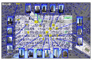
You know we have great maps, but here are examples
of how we take our map data and customize it for your specific use. Maps make great communication tools, whether you
are attempting to sell a house, or a shopping center!
|
|
|
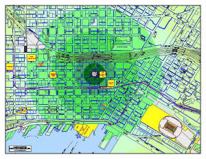
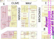
This custom overlay to our standard Seattle CBD involved
highlighting projected walking distances from a point in downtown Seattle. Various features within the scope of the
radius circle were highlighted to display distances in terms of walking time. The recipient of this map was concerned
about the proximity of certain features in relation to the proposed office space under consideration.
|
|
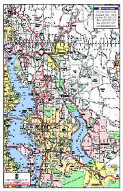
Need one of our standard maps, which just the coverage
you need, to pass out to prospective clients? Many real estate offices use our maps with their office information and
logo as promotional pieces to hand out, or send to clients. Individual agents can have these maps customized with their
specific information in quantities of 250 or more.
|
|
|
|
Data base driven mapping programs, with automated displays,
often fall short with regard to providing high-quality mapping. Give your client a clear idea of the demographic qualities
of the area you are promoting with a clear and concise Kroll base map.
|
|
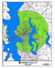
Distances and relationships to other features take
on a new perspective when graduated color radius circles are introduced as a custom overlay to our mapping. Such relationships
can be communicated around any feature type whether a building, an interchange, or a physcial feature.
|
|
|
|
Often times our clients will supply us with custom graphics
with the intent of embedding the images in our mapping. These graphics can take the form of corporate logos, building
photos, among others. Combining an easy-to-read map, with just the information you need, coupled with graphics that
provide added perspective, make for a very effective communication piece.
|
|
For some clients we are asked to represent data base
information on our parcel maps, commonly from the Assessor's information. Please note the example below, where
we have added the King County Assessor parcel identify centered in the parcel information. Please also note that there
is a highlight based on a query to that data base of apartments (over 3 units) and condominiums.
|
|
|
|
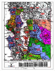
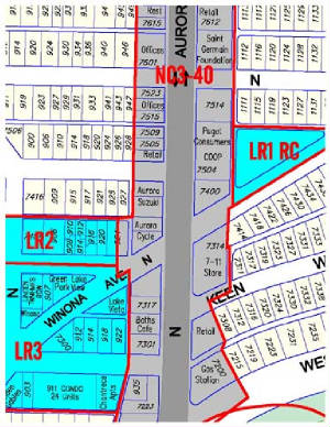
A common request from our real estate clients is to
provide mapping which focus on, and highlights areas with specified commercial zoning desginations. A quick query
in GIS will create the desired coverage area(s) which can easily be incorporated into our Integrated Map coverage. This
adjoining sample represents a request of allow our client to easily find parcels that are zoned LR (1 RC, 2, and 3) and
NC3-40. Client receives a great custom base map from which one can also identify addresses, business names, streets.
Assessor parcel numbers are available for large scale maps.
|
|
|
|
|
|
|
|
|