|
WHAT IS A TOWNSHIP MAP?
A township map covers
an area 6 by 6 miles (as specified by the Public Land Survey), and is defined by the township and range coordinates mapped
out from established meridians and base lines. These maps were generally drafted at a scale of 2"= 1 mile, and
often displayed parcels of land down to 10 acres in size. Numerous publishers, including Kroll, compiled such maps by
county, assigning page numbers to each township and range.
|
|
Kroll has an archive of these township maps that
includes numerous Washington State Counties. A list of these counties is below.
|
|

|
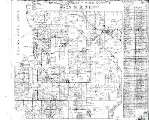
This example, from Kroll's 1912 King County Township
Atlas, depicts the area that is now downtown Bellevue. Please note how these maps illustrate roads, rail lines, and
old place names, as well as the land ownership information.
|
|
The following are the available Kroll township
maps. Orders can be placed by phone at (206) 448-6277, or by email at info@krollmap.com. Please specify map by township and range. Map pages are printed out at approximately twice the drafted
scale of 2"= 1 mile (for legibility). Printed maps are $14.95 each; digital versions for non-commercial use are
$29.00 each.
1) Surveyor General Township Maps:
These are drafters' copies of the maps
that delineated the township breakdowns for Washington State. Most maps are pre-1890, and are not available for the
entire state. Please contact us for availability.
2) Homestead Tract Maps:
These
depict original homestead claims, with numbers and often old geographic features. Only available for certain areas in
Washington State. Please contact us for availability.
3) Kroll Township Maps:
Clallam
County - 1928
Clark County - 1932
Cowlitz County - 1927
Grays Harbor County - 1928
Jefferson County -
1928
Kitsap County -1935
Kittitas County - 1932
King County - 1912, 1930, 1950, 1958, 1971
Lewis County
- 1926
Mason County - 1927
Pacfic County - 1926/1937 *
Pierce County - 1928
San Juan County - 1932
Skagit County - 1928
Skamania County - 1928
Snohomish County - 1952, 1960
Wahkiakum County - 1923
Whatcom
County - 1934/1940/1947 *
Yakima County - 1956
* designates various dates of pages within the set, not complete
sets with separate publication dates.
Download samples (3 different versions of the Bellevue
area):
download sample Surveyor General Township Map (Twp 25-Rn 05)
download sample Homestead Tract Map for (Twp 25-Rn 05)
download sample Kroll 1912 Township Map (Twp 25-Rn 05)
|
|