Mapping for Homeowners Associations

webassets/KLAHANIE_HOMEOWNERS_ASSOCIATION_BASE_MAP_pdf_11_X_17__1_.jpg

This map was prepared for a local homeowners association in east King County.  The drawing clearly illustrates all parcels, and includes "hidden" layers with assessor parcel information and addressing.  The client requested that these maps be multi-use, and include separate PDF versions of the 24 individual subdivisions within the development.  This map also includes trail information and facility information.

webassets/Alpental_2006.jpg

This map was created in the late 1980's and is still being revised on a regular basis for the community association.  The original map was drawn using coordinate geometry and includes the owners names.  The map is delivered as a PDF to the association.

webassets/Timberline_Community_Club-Model.jpg

Another Homeowner's association requested overlays to our traditional Kroll plat maps that include division name, lot number, and lot dimensions.  Color-coding of each division in this development has rendered a useful product for this residential community.

webassets/LFPlowres.JPG

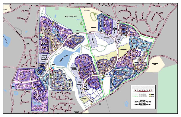
A homeowners association in north King County contacted us with a need to provide mapping that illustrates eligibility towards certain amenities within their community property.  In order to provide the boundary information necessary for this map, Kroll researched the original subdivision plat boundaries of all of the divisions involved and represented those boundaries in relation to current King County Assessor parcels.  In addition Kroll was provided a list of other eligible parcels, and using the parcel identifier number performed a simple GIS query to extract those lots that were to be highlighted on the map.

The map was printed at several sizes and also delivered in PDF for download on the homeowner's association web site.

Return to Kroll Home Page