|
|
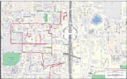
| Routes Displayed on Kroll IM |
|
|
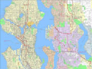
| Routes Displayed on Generalized Street Base |
|
A major fiber optics company requested that their routes
be transfered from existing Google KML formats to multi-layer Kroll Maps. For high-density areas Kroll overlaid routes
on the detailed IM base and for a more regional perspective, Kroll used the detailed street base as a visual medium to represent
the route structure that encompasses the extents of Lake Washington and extends into Snohomish County.
|
|
|
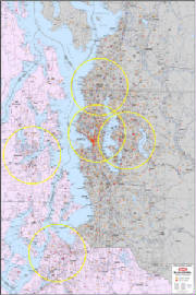
| Puget Sound Arterial Base with Cell Tower Locations |
|

|
| Washington and Oregon Regions with Cell Tower Sites. |
|
A spreadsheet with thousands of cell tower locations
quickly morphed into high-end cartogarphy diplaying points as spatially correct symbols. Cell towers were sorted by
type, reprojected in GIS, and displayed with the location ID. Our client also requested that maintenance zones be displayed
with the locations on both local and regional map bases.
|
|
|
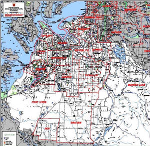
A major telecommunications firm, one that we have served
for over 80 years, approached us regarding representing their facilities on our maps. Historical boundary information
was also represented as well as current service area for each of their territories. Symbols were sorted based on a client
request for stratification by volume breakdowns. The various categories of locations were identified
by number, which correlated to the original data base. The client received these maps as scalable, vector PDFs.
|